Introduction
The Boreal Shield is Canada's largest terrestrial ecozone. It is approximately 1 800 000 kilometers squared making it roughly 20% of Canada's land mass. The Shield covers northern parts of Saskatchewan, the middle section of Manitoba, all of Ontario except for an area close to Hudson Bay, a large southern portion of Quebec, a few parts of Labrador and all of Newfoundland. The name Boreal Shield comes from its corresponding physiography region and natural vegetation region region. In other words, the "Shield" from Canadian Shield and "Boreal" from Boreal and Taiga forest were combined together to make the name Boreal Shield. Since it is such a wide region, there are varying climates, soils, natural vegetation all across the Boreal Shield. That is what makes it such a diverse and interesting region to study.
Physical Geography
Overall Climate
Due to the fast that the Boreal Shield is such a large ecozone, there is varying climate. However, influences on climate should be taken into consideration first. One factor that affects climate is latitude. Since this region is in the shape of a "U" (due to the Hudson's Bay and James Bay), the tops of this "U" are at higher latitudes giving some areas of this region, such as Northern Saskatchewan and Alberta, a colder climate. This can be explained by the fact that regions further away from the equator experience colder climate. Another factor, ocean currents does not influence climate in this region. However, when the cold Labrador current meets the warm currents originating on the gulf of Mexico, fog is created. Boats traveling in the Newfoundland and Labrador area must take special precautions to avoid collisions during more than 100 days of the year. Winds and air masses also greatly affect this region. Continental arctic, maritime arctic, and maritime polar winds affect this region. Moist air masses originating in the Atlantic Ocean give Newfoundland and other Maritime regions abundant precipitation. Elevation and relief precipitation do not affect this region due to the fact that its only mountains, the Appalachians have been greatly eroded over the centuries. Finally, one last factor that affects climate in this region is nearness to water. Areas in the Boreal Shield that border that Great Lakes and the Atlantic Ocean are warmed in winter and cooled in summer because land heats up faster than water. Taking these affects into consideration, I will now discuss the overall climate of this region . Summers throughout this region have an average temperature of 13°C. Winters in the Maritime region have an average temperature at only -1°C while continental winters in this region average at -20°C. In terms of precipitation, areas in the East have yearly precipitation amounts of 400 mm while in the West, precipitation can be as high as 1600 mm.
Climate Graph-Analysis
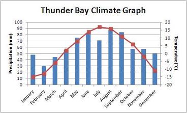
Due to the fact that the Boreal Shield is such a vast ecozone, I decided to pick a city around the middle and make and analyse a climate graph of that city.
Precipitation
-Winter: 50 mm
-Dry:Winter |
Temperature
|
Physiography
The main corresponding physiographic region of the Boreal Shield is the Canadian Shield. The Canadian Shield is the largest physiographic region in Canada. It occupies approximately 4 800 000 square kilometers of Canada. The shield has some of the oldest and hardest rock in the world. There is rock in this region that was formed 4 billion years ago. This was the time of the Precambrian era. That is why the shield is sometimes known as the Precambrian Shield. The rock types that it is made of are Igneous and Metamorphic. Igneous rock is made through the process of magma or lava cooling. Metamorphic rock is formed by heat heat and pressure (metamorphism) applied to igneous or sedimentary rock. There are also mineral deposits in the rock of the Canadian Shield which became present through the following process. Firstly, magma with dissolved minerals gradually rose to the surface. It flowed into cracks and cavities in the rock. As it cooled into Igneous rock, the various minerals present in the magma became part of the rock. The shield is also dotted with lakes because of glaciation. Presently, the general physiography of the shield is rolling hills due to centuries of erosion. (The shield was once made of very tall mountains) The other two physiographic regions that make up the Boreal Shield (in very portions) are the Great Lakes-St. Lawrence lowlands region as well as the appalachians.
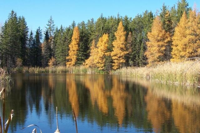
Vegetation-Natural and Human Influnced
The natural vegetation region that corresponds with the Boreal Shield is the Boreal and Taiga forest. According to the triangular graph of physiography, climate, soils and natural vegetation influence each other. In this case, the climate of this region influences the natural vegetation. The reason why this occurs is because the cold and fairly dry climate of this region allow almost no deciduous trees to grow and therefore, only coniferous trees are able to survive in this harsh climate. Some examples of coniferous trees that grow in this region are balsam fir, white spruce, black spruce, and tamarack. Deciduous trees that grow in this region, primarily in the warmer South, include white birch, trembling aspen, and balsam poplar. As this region is so diverse, lichens and shrubs grow in areas of exposed bedrock. Approximately 85% of the Boreal Shield is covered by forest despite the fact that the climate is so cold and dry influence. There is an average of 60-100 frost-free days a year in this ecozone. 100 days per year are required in order for grain and other crops to grow. That is why there are not very many farms in this region.
Soil
The soil region that corresponds to the Boreal Shield is "wet-climate soils". However, there are many more specific characteristics to this soil. They are thin and very acidic. The main reason why they are acidic is because of the large number of coniferous trees. This brings us back to the triangular graph of physiography. In this case, the vegetation influences the soil, in that the needles from the great amount of coniferous trees gives the soil of that region its acidity. Another characteristic of the soil is that it has very little humus or air. These factors lead to the fact that there are not many farms in this region.
Human Geography
Human influence to the region
There are many industries that continue to thrive in the Boreal Shield. Firstly, there is the forestry industry. 85% of the Boreal Shield is covered by forests and 400 000 hectares are harvested per year. Another industry is the mining industry. The shield provides 75% of Canada's iron, nickel, copper, gold and silver. That is one of the reasons why its corresponding physiographic region, the Canadian Shield, is known as Canada's storehouse of metallic minerals. Canada is also the largest producer of hydroelectricity in the world. 39% of Canada's hydroelectricity comes from the Boreal Shield. Other smaller industries include hunting, trapping, fishing, and water oriented tourism. The agriculture industry exists only where the soil and climate are suitable. Despite these many industries, the majority of employment comes from the service, public administration, wholesale and retail sectors.
Animals
The Boreal Shield is a very large ecozone and therefore, it includes a variety of different animals. From amphibians to reptiles to birds, there is an unbelievable amount of biodiversity in this vast region. Here is a list of just some of the many animals in the shield:Black bear, lynx, marten, woodland caribou, moose, raccoon, eastern chipmunk, white-tailed deer, fisher, striped skunk,bobcat, blue jay, warbler, owl, and loon.
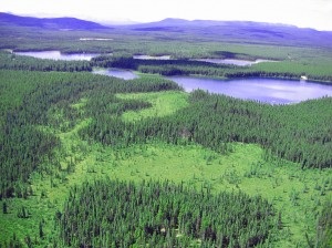
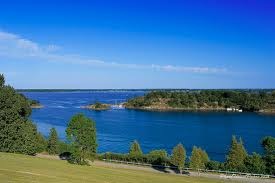
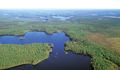
Various Pictures of the Boreal Shield
|

|
|
|
|
